About i-Tree Landscape
Welcome to the powerful mapping tool known as i-Tree Landscape. Quickly explore at scales from community trees to regional forests. Learn the physical and monetary benefits trees provide to their surroundings. Go deeper: assess potential threats, discovery improvement opportunities, and construction action plans by utilizing the crafted resources within.
To accomplish all of this, i-Tree Landscape enables easy merging of data from the US Forest Service, US Census Bureau, US Environmental Protection Agency, US Geological Survey, US National Oceanic and Atmospheric Administration, and other sources at scales including census block groups, watersheds, congressional districts, national forests, and the usual administrative boundaries such as cites and states. Now you can identify priorities at scales meaningful to you, and build reports to justify your case for tree stewardship!
Users of i-Tree Landscape can explore the risks of fire, insects, flood, extreme heat, and urban development in relation to resident income, education, diversity, and home ownership in combination with carbon dioxide removal, urban heat moderation, storm water interception, and air pollution reduction. Some examples of the questions that users can answer, include:
- Across multiple U.S. Census block groups, where should I target my community outreach with the greatest potential to recruit volunteers for land stewardship and tree planting?
- Across multiple HUC 12 watersheds, when evaluating drainage connecting public lands and residential neighborhoods, where is the fire and development risk the greatest, and where should I target my work to have the greatest likelihood of protecting vulnerable populations and habitat corridors?
- Based on our forest type and identified pests, which communities in my county are at the greatest risk for infestation and tree mortality?
- Across multiple communities, where is the lowest trees per capita with the greatest amount of potential planting space?
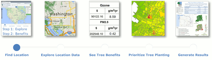
The pages go through selecting locations of interest, exploring their maps and data, learning the benefits of their trees, prioritizing planting and conservation efforts, and generating custom reports.
Click Get Started to begin an i-Tree Landscape project now!
About i-Tree
i-Tree is state-of-the-art, peer-reviewed research, and associated software suite from the USDA Forest Service. Learn more on its homepage.
If you find i-Tree useful, please consider donating or partnering with us to support its continued development.
Contact Us
Use the feedback form to reach us.